PAUWES Data Portal
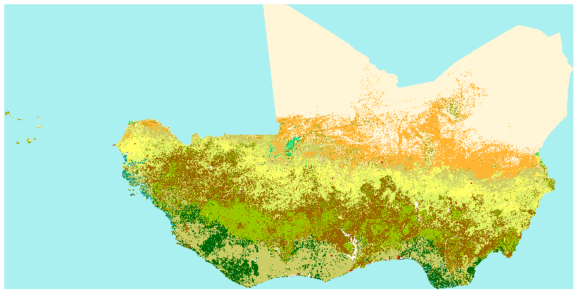
Land Cover
The Africa land cover map is a regional component of the GLC2000 exercise, conceived and coordinated by the European Commission’s Joint Research Centre.
From the Africa land cover map, which is a regional component of the GLC2000 exercise, conceived and coordinated by the European Commission’s Joint Research Centre. The GLC2000 maps are based on daily observations made from 1st November 1999 to 31st December 2000 by the VEGETATION sensor on the SPOT 4 satellite.
Legend- definition of the Gray index value:
-11: post-flooding or irrigated croplands
-14: rainfed croplands
-20: mosaic cropland (50-70%) / Vegetation (grassland, shrubland, forest) (20-50%)
-30: mosaic vegetation (grassland, shrubland, forest) (50-70%) / cropland (20-50%)
-40: closed to open (>15%) broadleaved evergreen and/or semi-deciduous forest (>5m)
-50: closed (>40%) broadleaved deciduous forest (>5m)
-60: open (15-40%) broadleaved deciduous forest (>5m)
-70: closed (>40%) needleleaved evergreen forest (5m)
-90: open (15-40%) needleleaved deciduous or evergreen forest (5m)
-100: closed to open (>15%) mixed broadleaved and needleleaved forest (>5m)
-110: mosaic forest / shrubland (50-70%) / grassland (20-50%)
-120: mosaic grassland (50-70%) / forest/shrubland (20-50%)
-130: closed to open (>15%) shrubland (<5m)
-140: closed to open (>15%) grassland
-150: sparse (>15%) vegetation (woody vegetation, shrubs, grassland)
-160: closed (>40) broadleaved forest regularly flooded- fresh water
-170: closed (>40%) broadleaved semi-deciduous and/or evergreen forest regularly flooded- saline water
-180: closed to open (>15%) vegetation (grassland, shrubland, woody vegetation) on regularly flooded or waterlogged soil- fresh, brackish or saline water
-190: artificial surfaces and associated areas (urban areas >50%)
-200: bare areas
-210: water bodies
-220: permanent snow and ice
Simple
- Date (Publication)
- 2001-01-09T00:00:00
- Presentation form
- Digital map
- Status
- Completed
- Maintenance and update frequency
- Unknown
- Theme
-
- West Africa, ECOWAS
- Landcover, Landcover 2000
- JRC
- Soil use
- Vegetation, Urban areas, Forest
- SPOT vegetation
- Agriculture
- Forest
- Access constraints
- Copyright
- Other constraints
-
Copyright notice
© European Union, 1995-2016
Reuse is authorised, provided the source is acknowledged. The Commission's reuse policy is implemented by the Decision of 12 December 2011 - reuse of Commission documents [PDF, 728 KB].
The general principle of reuse can be subject to conditions which may be specified in individual copyright notices. Therefore, users are advised to refer to the copyright notices on individual websites maintained under Europa and in individual documents. Reuse is not applicable to documents subject to intellectual property rights of third parties.
- Spatial representation type
- Grid
- Denominator
- 20000000
- Metadata language
- English
- Topic category
-
- Environment
- Begin date
- 1999-11-01
- End date
- 2000-12-31
))
- Reference system identifier
- WGS 84 (EPSG:4326)
- Distribution format
-
-
OGC:OWS-C
(
)
-
OGC:OWS-C
(
)
- OnLine resource
- Joint Research Centre: Global Land Cover 2000 ( WWW:LINK-1.0-http--link )
- OnLine resource
- http://www.ecowrex.org/mapView/?mclayers=layerLandCover ( WWW:LINK-1.0-http--link )
Conformance result
- Date (Publication)
- File identifier
- 7f84a26b-3be5-46a7-8150-b1fd0d1785b0 XML
- Character set
- UTF8
- Hierarchy level
- Service
- Date stamp
- 2016-11-09T15:57:33
Overviews
Spatial extent
Provided by