PAUWES Data Portal
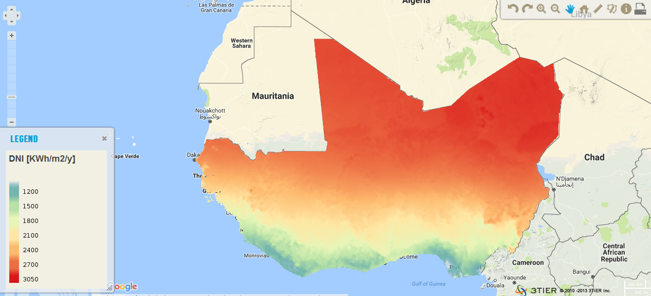
Solar Direct Normal Irradiance (KWh/m2/year) resource in West Africa
The resource was developed by CENER (The National Renewable Energy Center, Spain) for ECREEE. High resolution data of 1km x 1km developed using Numerical Weather Prediction (NWP) model from hourly meteorological weather files of over 10 years.
Dataset is provided in raster format (.geotiff) at a resolution of 1 km.
It ranges from 1200 to 2800 KWh/m2/year. Around 87% of the total surface of the ECOWAS region has long term annual DNI values greater than 1800 KWh/m2.
Simple
- Date (Publication)
- 2012-09-01T00:00:00
- Presentation form
- Digital map
- Status
- Completed
- Maintenance and update frequency
- Irregular
- Theme
-
- DNI, solar resource
- ECOWAS, West Africa
- Renewable energy resource
- GeoTIFF
- Solar, Power plant, energy, PV
- CENER
- Access constraints
- License
- Other constraints
- The dataset is licensed under the Creative Commons Attribution-Share Alike 4.0 International license. You are allowed to: • Share : to copy, distribute and transmit the work • Remix : to adapt the work Under the following conditions: • Attribution – You must attribute the work giving reference to the original source. • Share alike – If you alter, transform, or build upon this work, you may distribute the resulting work only under the same or similar license to this one.
- Spatial representation type
- Grid
- Denominator
- 20000000
- Metadata language
- English
- Topic category
-
- Geoscientific information
- Begin date
- 2012-09-01
- End date
- 2012-12-22
))
- Reference system identifier
- WGS 84 (EPSG:4326)
- Distribution format
-
-
OGC:OWS-C
(
)
-
OGC:OWS-C
(
)
- OnLine resource
- http://www.ecowrex.org/mapView/?mclayers=layerDNI ( WWW:LINK-1.0-http--link )
- OnLine resource
-
11.1124 - Solar resource map of ECOWAS.pdf
(
WWW:DOWNLOAD-1.0-http--download
)
Report and methodology
- OnLine resource
-
ecreee_dni
(
OGC:WMS
)
Direct Normal Solar Irradiance (DNI) map for West Africa
Conformance result
- Date (Publication)
- File identifier
- a6d0e5cd-d259-4872-86ce-6ae8aefe7704 XML
- Character set
- UTF8
- Hierarchy level
- Service
- Date stamp
- 2018-03-22T13:16:17
Overviews
Spatial extent
Provided by