PAUWES Data Portal
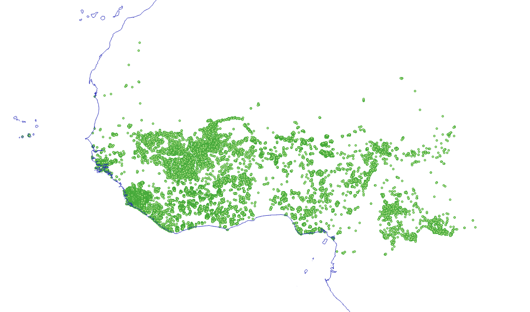
Identified settlements for mini-grids by 2030
Simple
- Date (Publication)
- 2019-10-16
- Presentation form
- Digital map
- Status
- Completed
- Maintenance and update frequency
- As needed
- Theme
-
- electrification
- settlements
- localities
- towns
- energy access
- electricity access
- rogep
- mini-grid
- rural electrification
- energy access
- Access constraints
- License
- Other constraints
- The dataset is under Creative Commons Attribution-ShareAlike 4.0 International License. You are free to: Share — copy and redistribute the material in any medium or format; Adapt — remix, transform, and build upon the material for any purpose, even commercially. Under the following terms: Attribution — You must give appropriate credit, provide a link to the license, and indicate if changes were made. You may do so in any reasonable manner, but not in any way that suggests the licensor endorses you or your use; ShareAlike — If you remix, transform, or build upon the material, you must distribute your contributions under the same license as the original; No additional restrictions — You may not apply legal terms or technological measures that legally restrict others from doing anything the license permits.
- Spatial representation type
- Vector
- Denominator
- 20000000
- Metadata language
- English
- Topic category
-
- Geoscientific information
- Society
- Economy
- Utilities communication
- Begin date
- 2018-04-01
- End date
- 2019-03-31
))
- Supplemental Information
-
Methodology:
- Settlements located within 15 km of economic growth center (airports, mines, urban areas), have a population above 350 people per square kilometer, identified as mini-grid settlements in scenario 2023 and located within 1 km of a defined mini-grid in scenario 2023
- For the detailed methodology see report: ‘Regional Off-Grid Solar Market Assessment & Private Sector Support Facility Design – Regional Report
- For the sources of data see report: 'Regional Off-Grid Solar Market Assessment & Private Sector Support Facility Design - Country reports.
- Reference system identifier
- WGS 84 (EPSG:4326)
- Distribution format
-
-
ESRI Shapefile
(
not specified
)
-
ESRI Shapefile
(
not specified
)
- OnLine resource
- ECOWREX map viewer ( WWW:LINK-1.0-http--link )
- OnLine resource
-
minigrid_ecowas_2023
(
OGC:WFS
)
minigrid_ecowas_2023
- File identifier
- d20079b0-385b-4382-925b-ca1f951e15ce XML
- Character set
- UTF8
- Date stamp
- 2019-12-04T15:36:38
Overviews
Spatial extent
Provided by