PAUWES Data Portal
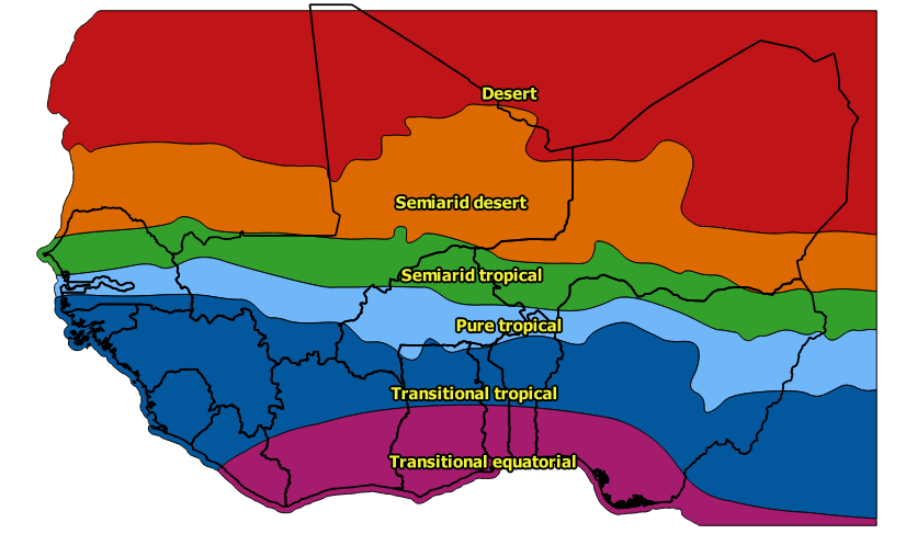
Climatic zones in West Africa
This dataset shows the extent of six climatic zones for West Africa.It is not intended for local studies but only for regional comparison.
It was created using the following methodology:
1. A climatic zones classification was determined based on an existing classification by L’Hôte et al. 1996 that has been developed with a special focus on West Africa and applicability for hydrological purposes, summarizing and consolidating many previous attempts of classifying West African climate. The classification is widely used in regional studies, as e.g. in the Andersen et al. 2005 study on the Niger River Basin, from which the English denominations of the originally French climatic zone names were derived. Climatic zone limits are based on mean annual and seasonal precipitation:
1) Desert: Mean Annual Precipitation (MAP) < 100 mm
2) Semiarid desert: MAP < 400 mm
3) Semiarid tropical: MAP < 700 mm
4) Pure tropical: MAP < 1000 mm
5) Transitional tropical: MAP > 1000 mm, one wet season
6) Transitional equatorial: MAP > 1000 mm, two wet seasons
2. The geographical location of the climatic zone boundaries was derived from the long-term annual mean of daily precipitation data for 1998-2014 of the Tropical Rainfall Measuring Mission (TRMM, a joint U.S.-Japan satellite mission to monitor tropical and subtropical precipitation). Limits between zone 5, transitional tropical climate, and zone 6, transitional equatorial climate, were adopted from the map of L`Hôte et al. 1996. Their limits are based on seasonal precipitation and on previous climate zone classification limits.
3. The resulting polygons were generalized (smoothing of polygon boundaries, removal of islands).
The climate change projections were extracted from 30 Regional Climate Model (RCM) runs included in the CORDEX-Africa ensemble for the representative concentration pathways RCP4.5 and RCP8.5. Future change in potential evapotranspiration was estimated using an empirical relationship between air temperature and potential evapotranspiration
For each climatic zone the following attributes are available:
• CLZ_ID: ID of climatic zone
• NAME_FR: Climatic zone denomination in French
• NAME_ENG: Climatic zone denomination in English
• PRECIP_Y: Mean annual precipitation (mm) in the period 1998-2014
• TEMP_Y: Mean annual air temperature (°C) in the period 1998-2014
• ETP_Y: Mean annual potential evapotranspiration (mm) in the period 1998-2014
• P_2035_P25: Change in future mean annual precipitation in % (2026-2045 vs. 1998-2014) for the lower quartile projection of 30 climate model runs in the CORDEX-Africa ensemble (RCP4.5 and RCP8.5)
• P_2035_P50: Change in future mean annual precipitation in % (2026-2045 vs. 1998-2014) for the median projection of 30 climate model runs in the CORDEX-Africa ensemble (RCP4.5 and RCP8.5)
• P_2035_P75: Change in future mean annual precipitation in % (2026-2045 vs. 1998-2014) for the upper quartile projection of 30 climate model runs in the CORDEX-Africa ensemble (RCP4.5 and RCP8.5)
• P_2055_P25: Change in future mean annual precipitation in % (2046-2065 vs. 1998-2014) for the lower quartile projection of 30 climate model runs in the CORDEX-Africa ensemble (RCP4.5 and RCP8.5)
• P_2055_P50: Change in future mean annual precipitation in % (2046-2065 vs. 1998-2014) for the median projection of 30 climate model runs in the CORDEX-Africa ensemble (RCP4.5 and RCP8.5)
• P_2055_P75: Change in future mean annual precipitation in % (2046-2065 vs. 1998-2014) for the upper quartile projection of 30 climate model runs in the CORDEX-Africa ensemble (RCP4.5 and RCP8.5)
• T_2035_P25: Change in future mean annual air temperature in °C (2026-2045 vs. 1998-2014) for the lower quartile projection of 30 climate model runs in the CORDEX-Africa ensemble (RCP4.5 and RCP8.5)
• T_2035_P50: Change in future mean annual air temperature in °C (2026-2045 vs. 1998-2014) for the median projection of 30 climate model runs in the CORDEX-Africa ensemble (RCP4.5 and RCP8.5)
• T_2035_P75: Change in future mean annual air temperature in °C (2026-2045 vs. 1998-2014) for the upper quartile projection of 30 climate model runs in the CORDEX-Africa ensemble (RCP4.5 and RCP8.5)
• T_2055_P25: Change in future mean annual air temperature in °C (2046-2065 vs. 1998-2014) for the lower quartile projection of 30 climate model runs in the CORDEX-Africa ensemble (RCP4.5 and RCP8.5)
• T_2055_P50: Change in future mean annual air temperature in °C (2046-2065 vs. 1998-2014) for the median projection of 30 climate model runs in the CORDEX-Africa ensemble (RCP4.5 and RCP8.5)
• T_2055_P75: Change in future mean annual air temperature in °C (2046-2065 vs. 1998-2014) for the upper quartile projection of 30 climate model runs in the CORDEX-Africa ensemble (RCP4.5 and RCP8.5)
• E_2035_P25: Change in future mean annual potential evapotranspiration in % (2026-2045 vs. 1998-2014) for the lower quartile simulation using 30 climate model runs of the CORDEX-Africa ensemble (RCP4.5 and RCP8.5)
• E_2035_P50: Change in future mean annual potential evapotranspiration in % (2026-2045 vs. 1998-2014) for the median simulation using 30 climate model runs of the CORDEX-Africa ensemble (RCP4.5 and RCP8.5)
• E_2035_P75: Change in future mean annual potential evapotranspiration in % (2026-2045 vs. 1998-2014) for the upper quartile simulation using 30 climate model runs of the CORDEX-Africa ensemble (RCP4.5 and RCP8.5)
• E_2055_P25: Change in future mean annual potential evapotranspiration in % (2046-2065 vs. 1998-2014) for the lower quartile simulation using 30 climate model runs of the CORDEX-Africa ensemble (RCP4.5 and RCP8.5)
• E_2055_P50: Change in future mean annual potential evapotranspiration in % (2046-2065 vs. 1998-2014) for the median simulation using 30 climate model runs of the CORDEX-Africa ensemble (RCP4.5 and RCP8.5)
• E_2055_P75: Change in future mean annual potential evapotranspiration in % (2046-2065 vs. 1998-2014) for the upper quartile simulation using 30 climate model runs of the CORDEX-Africa ensemble (RCP4.5 and RCP8.5)
The following tools were used for creating this dataset:
• ArcGIS 10.0: Conversion of raster data sets to polygons, smoothing and generalization of polygons
• ArcGIS 9.2: Definition of interpolation points
• ArcView 3.1: Data import of large raster data sets
• Fortran: Calculation of mean annual and mean monthly values of climatic variables for West Africa
• MS Excel: Data pre-processing and visualization
• Libre Office: Manipulation of dbf data tables
• CDO: Climate Data Operators for processing of CORDEX-Africa climate model data
• Shell scripts: For automatic file processing of climate model data
• Batch scripts: For automatic calls to Fortran programs
Simple
- Date (Publication)
- 2016-06-29T00:00:00
- Presentation form
- Digital map
- Status
- Completed
- Maintenance and update frequency
- As needed
- Theme
-
- Climate
- Climatic zones
- West africa
- Evapotranspiration
- Temperature
- Precipitation
- Water balance
- Climate change
- Access constraints
- License
- Other constraints
-
The dataset is licensed under the Creative Commons Attribution-Share Alike 4.0 International license. You are free: (1) to share – to copy, distribute and transmit the work
and (2) to remix – to adapt the work; Under the following conditions: (1) attribution – You must attribute the work giving reference to the original source. (2) share alike – If you alter, transform, or build upon this work, you may distribute the resulting work only under the same or similar license to this one
- Spatial representation type
- Vector
- Denominator
- 10000000
- Metadata language
- English
- Topic category
-
- Climatology, meteorology, atmosphere
- Begin date
- 1997-12-30
- End date
- 2014-12-29
))
- Supplemental Information
-
The following tools were used for creating this dataset:
• ArcGIS 10.0: Conversion of raster data sets to polygons, smoothing and generalization of polygons
• ArcGIS 9.2: Definition of interpolation points
• ArcView 3.1: Data import of large raster data sets
• Fortran: Calculation of mean annual and mean monthly values of climatic variables for West Africa
• MS Excel: Data pre-processing and visualization
• Libre Office: Manipulation of dbf data tables
• CDO: Climate Data Operators for processing of CORDEX-Africa climate model data
• Shell scripts: For automatic file processing of climate model data
• Batch scripts: For automatic calls to Fortran programs
- Reference system identifier
- WGS 84 (EPSG:4326)
- Distribution format
-
-
ESRI Shapefile
(
1.0
)
-
ESRI Shapefile
(
1.0
)
- OnLine resource
- ECOWREX map viewer ( WWW:LINK-1.0-http--link )
- OnLine resource
-
final_technical_report_on_methodology_and_lessons_learnt_for_ecowas_countries.pdf
(
WWW:DOWNLOAD-1.0-http--download
)
Technical Report on data sources, methodology and lessons learnt
- OnLine resource
- Results of ECOWAS Small Scale Hydropower Program ( WWW:LINK-1.0-http--link )
- OnLine resource
-
climatic_zones_westafrica
(
OGC:WMS
)
climaticzones
Conformance result
- Date (Publication)
- File identifier
- e1b86c2d-1c64-4d85-a0c9-dfa8b3240d3e XML
- Character set
- UTF8
- Date stamp
- 2018-03-22T11:48:03
Overviews
Spatial extent
Provided by