 PAUWES Data Portal
irregular
Keywords
Regions
Contact for the resource
Provided by
Years
Formats
Representation types
Update frequencies
status
Scale
-

The WASCAL Data Management Plan (DMP) describes the data to be created in WASCAL and the measures, methods, tools, standards and rules to warrant its proper management, archiving and exchange over the long term. The DMP was written at the beginning of the WASCAL project in 2012 by using information on data collection campaigns planned by scientists in the WASCAL Core Research Program and on bio-physical time series data to be provided by observation networks in the 10 WASCAL member countries.
-
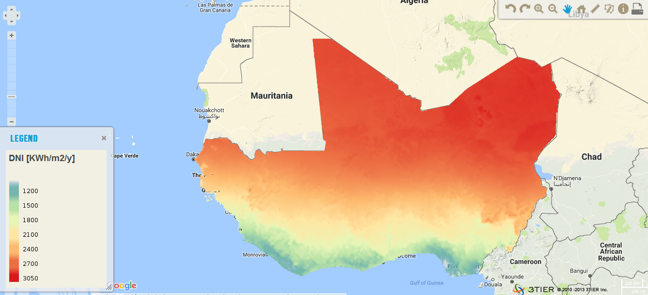
The resource was developed by CENER (The National Renewable Energy Center, Spain) for ECREEE. High resolution data of 1km x 1km developed using Numerical Weather Prediction (NWP) model from hourly meteorological weather files of over 10 years. Dataset is provided in raster format (.geotiff) at a resolution of 1 km. It ranges from 1200 to 2800 KWh/m2/year. Around 87% of the total surface of the ECOWAS region has long term annual DNI values greater than 1800 KWh/m2.
-

The meteorological dataset consists of uncorrected half-hourly meteorological measurements for seven climate stations and three eddy covariance stations. The stations belong to the hydro-meteorological network established for the Vea and Sissili watershed in Southern Burkina Faso and Northern Ghana. The dataset contains seven meteorological variables: the mean incoming shortwave radiation [W/m2], the mean incoming longwave radiation [W/m2], the mean air temperature [°C], the mean horizontal wind speed [m/s], the mean horizontal wind direction [°], the mean air pressure [hPa], the mean relative humidity [g/kg] and the total precipitation amount [mm]. The data set is available from October 2012 to October 2016. More recent informatoin and other meteorological variables such as heat fluxes can be provided by request. Further information about the data sets and the meteorological network will be given in a future publication which was recently submitted to a special issue on “Hydrological Observatories” of the Vadose Zone Journal.
-
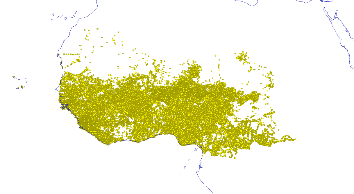
Location of settlements that could have access to electricity through off-grid solutions by 2023 according to the least-cost analysis conducted in the framework of the off-grid solar market assessment and private sector support facility design, which was done as an activity of the sub-component 1A of the Regional Off-Grid Electrification Project (ROGEP).
-

This gridded precipitation set is a test data set (BETA VERSION). The daily precipitation data set was created using a spatial interpolation technique using ordinary kriging. The gridded data set is based on 410 daily observed precipitation time series from stations located in Ghana, Benin, Togo, Burkina Faso and neighboring countries. They have been compiled from global (GHCN-daily), regional (e.g. AMMA-SYNOP, GLOWA-Volta) and national archives from the meteorological services of Burkina Faso, Ghana and Benin. The temporal coverage of the daily time series ranges from 1940 to 2013. The quality of the spatial interpolation was compared to various interpolation techniques (nearest neighbor, inverse distance and external drift kriging).
-
The meteorological dataset consists of infilled half-hourly meteorological measurements for seven climate stations and three eddy covariance stations. The stations belong to the hydro-meteorological network established for the Vea and Sissili watershed in Southern Burkina Faso and Northern Ghana. The dataset contains seven meteorological variables: the mean incoming shortwave radiation [W/m2], the mean incoming longwave radiation [W/m2], the mean air temperature [°C], the mean horizontal wind speed [m/s], the mean sea level pressure [hPa], the mean specific humidity [g/kg] and the total precipitation amount [mm]. The data set is available from 1st of October 2012 to 31st of December 2013. The infilling of measurements was done using a spatiotemporal infilling algorithm based on an inverse distance approach. Other meteorological information such as heat fluxes can be also provided by request. Further information about the data sets and the meteorological network will be given in a future publication which was recently submitted to a special issue on “Hydrological Observatories” of the Vadose Zone Journal.
-
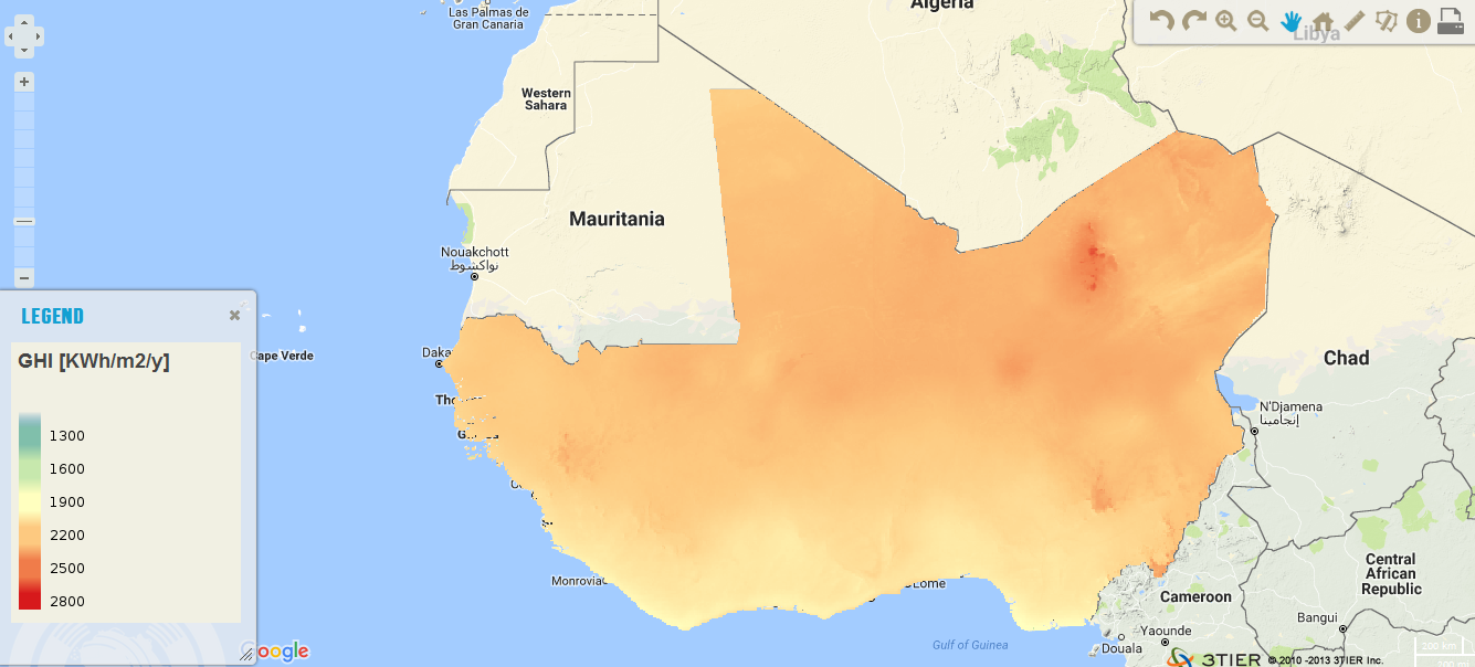
The resource was developed by NEXANT (EEUU) for ECREEE.using 3TiER global solar dataset with an annual temporal resolution. The project was funded by USAID. This parameter is of particular interest to photovoltaic installations and includes both Direct Normal Irradiance (DNI) and Diffuse Horizontal Irradiance (DIF). The format is raster (.geotiff) and the resolution is 3km.
-
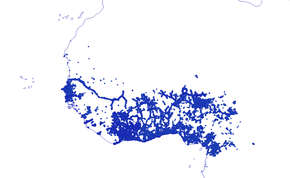
Location of settlements that could be connected to national electricity grids in 2023 according to the least-cost analysis conducted in the framework of the off-grid solar market assessment and private sector support facility design, which was done as an activity of the sub-component 1A of the Regional Off-Grid Electrification Project (ROGEP).