 PAUWES Data Portal
ECOWAS Centre for Renewable Energy and Energy Efficiency (ECREEE)
Keywords
Contact for the resource
Provided by
Years
Formats
Representation types
Update frequencies
status
Scale
-

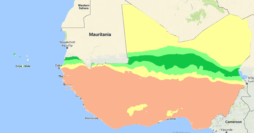
The resource was developed by NEXANT (EEUU) for ECREEE using 3TiER global dataset. The methodology is explained in the resource below available for downloading. Dataset is available in raster format (.geotiff) with a resolution of 3,5 km.
-

The data provides information about the development of the Gas Pipeline project for West Africa, including the gas station at each Member state. Data was compiled by ECREEE from the West African Gas Pipeline Company’s (WAPCO).
-
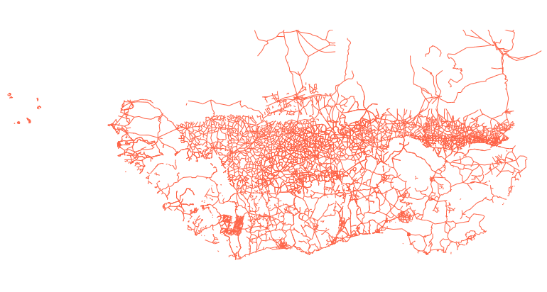
Estimated data of the entire primary and secondary road network in West Africa including the road surface type, condition and traffic volume in shapefile format. Data was compiled by TECSULT for the Infrastructure Consortium for Africa (ICA), a project which was led by the World Bank.
-
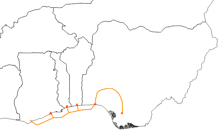
Data provides information about the development of the Gas Pipeline project for West Africa, including the gas station at each Member state. Compiled by ECREEE from the West African Gas Pipeline Company’s (WAPCO).
-
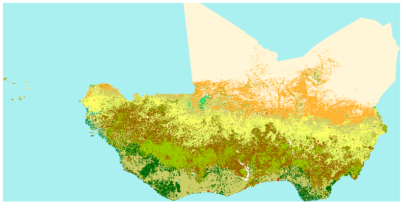
The Africa land cover map is a regional component of the GLC2000 exercise, conceived and coordinated by the European Commission’s Joint Research Centre. From the Africa land cover map, which is a regional component of the GLC2000 exercise, conceived and coordinated by the European Commission’s Joint Research Centre. The GLC2000 maps are based on daily observations made from 1st November 1999 to 31st December 2000 by the VEGETATION sensor on the SPOT 4 satellite. Legend- definition of the Gray index value: -11: post-flooding or irrigated croplands -14: rainfed croplands -20: mosaic cropland (50-70%) / Vegetation (grassland, shrubland, forest) (20-50%) -30: mosaic vegetation (grassland, shrubland, forest) (50-70%) / cropland (20-50%) -40: closed to open (>15%) broadleaved evergreen and/or semi-deciduous forest (>5m) -50: closed (>40%) broadleaved deciduous forest (>5m) -60: open (15-40%) broadleaved deciduous forest (>5m) -70: closed (>40%) needleleaved evergreen forest (5m) -90: open (15-40%) needleleaved deciduous or evergreen forest (5m) -100: closed to open (>15%) mixed broadleaved and needleleaved forest (>5m) -110: mosaic forest / shrubland (50-70%) / grassland (20-50%) -120: mosaic grassland (50-70%) / forest/shrubland (20-50%) -130: closed to open (>15%) shrubland (<5m) -140: closed to open (>15%) grassland -150: sparse (>15%) vegetation (woody vegetation, shrubs, grassland) -160: closed (>40) broadleaved forest regularly flooded- fresh water -170: closed (>40%) broadleaved semi-deciduous and/or evergreen forest regularly flooded- saline water -180: closed to open (>15%) vegetation (grassland, shrubland, woody vegetation) on regularly flooded or waterlogged soil- fresh, brackish or saline water -190: artificial surfaces and associated areas (urban areas >50%) -200: bare areas -210: water bodies -220: permanent snow and ice
-
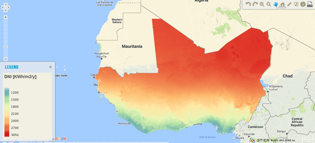
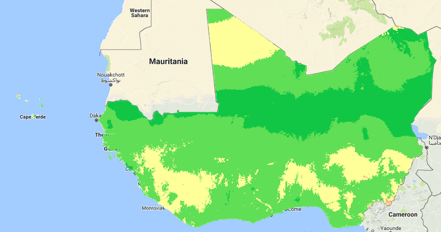
The resource was developed by CENER (The National Renewable Energy Center, Spain) for ECREEE. High resolution data of 1km x 1km developed using Numerical Weather Prediction (NWP) model from hourly meteorological weather files of over 10 years. Dataset is provided in raster format (.geotiff) at a resolution of 1 km. It ranges from 1200 to 2800 KWh/m2/year. Around 87% of the total surface of the ECOWAS region has long term annual DNI values greater than 1800 KWh/m2.
-
Data provides information about novel potential bio-energy crops which can or could be grown and processed in the future in the 15 ECOWAS countries. The project “Regional potential assessment of novel bio energy crops in fifteen ECOWAS countries” was started by the different project partners (ECREEE, UNIDO and QUINVITA) based on the need to make an overall assessment of a series of novel potential bio energy crops which can or could be grown and processed in the future in the 15 ECOWAS countries. This project fits in a broader strategic analysis of alternative energy needs and production, the key mandate of the mainfunding partner in the project, ECREEE. The project partners deliberately excluded conventional “bio energy” crops like sugarcane, oil palm, maize or sunflower as target crops, since they believed a sufficient knowledge base on the growing and processing crops was available globally and in the region. The novel bio energy crops chosen as targets for the study are a selection of crops for which either the agricultural knowledge is still limited and/or the use of the crop as an energy source is relatively new. The project team realizes that the list of selected crops is not an exhaustive list of potential bio energy crops and other novel crops may have a potential in the region. The project will develop a methodology that can be followed in the future for analyzing the potential of other crops and does not want to exclude this analysis in the future. The crops that have been selected for analysis in this project are: False Flax (Camelina sativa), Crambe (Crambe abyssinica), Cassava (Manihot esculenta), Castor bean (Ricinus communis), Cashew (Anacardium occidentale), Groundnut (Arachis hypogaea), Jatropha curcas and sweet sorghum (sweet version of Sorghum bicolor).
-
The layer provides quantitative information about the inhabitants main points in the different countries for the ECOWAS region
-
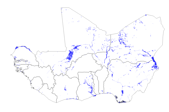
Main water areas in the ECOWAS region extracted from the DIVA-GIS project
-
Data provides information about novel potential bio-energy crops which can or could be grown and processed in the future in the 15 ECOWAS countries. The project “Regional potential assessment of novel bio energy crops in fifteen ECOWAS countries” was started by the different project partners (ECREEE, UNIDO and QUINVITA) based on the need to make an overall assessment of a series of novel potential bio energy crops which can or could be grown and processed in the future in the 15 ECOWAS countries. This project fits in a broader strategic analysis of alternative energy needs and production, the key mandate of the mainfunding partner in the project, ECREEE. The project partners deliberately excluded conventional “bio energy” crops like sugarcane, oil palm, maize or sunflower as target crops, since they believed a sufficient knowledge base on the growing and processing crops was available globally and in the region. The novel bio energy crops chosen as targets for the study are a selection of crops for which either the agricultural knowledge is still limited and/or the use of the crop as an energy source is relatively new. The project team realizes that the list of selected crops is not an exhaustive list of potential bio energy crops and other novel crops may have a potential in the region. The project will develop a methodology that can be followed in the future for analyzing the potential of other crops and does not want to exclude this analysis in the future. The crops that have been selected for analysis in this project are: False Flax (Camelina sativa), Crambe (Crambe abyssinica), Cassava (Manihot esculenta), Castor bean (Ricinus communis), Cashew (Anacardium occidentale), Groundnut (Arachis hypogaea), Jatropha curcas and sweet sorghum (sweet version of Sorghum bicolor).